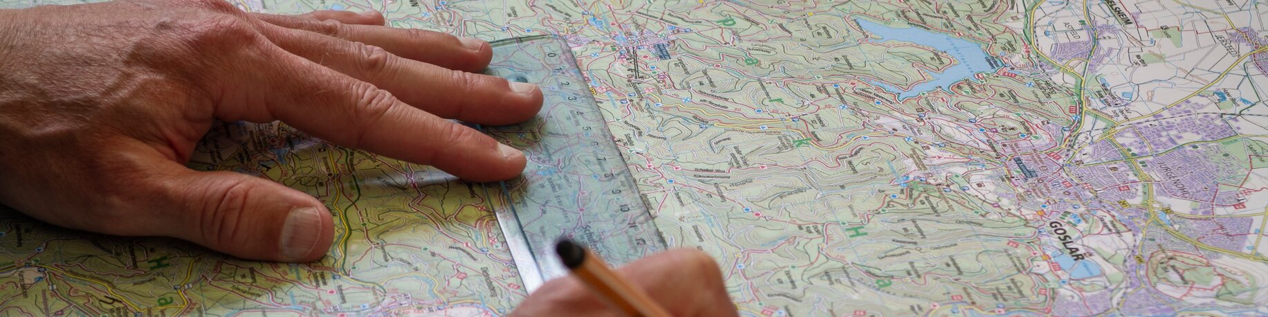
How is a hiking map made?
Social Wall
Produced in association with Kompass, a brand-new hiking map is now available for the Zugspitz Arena Bayern-Tirol. To mark the occasion, Thomas Kargl from Kompass explains how a hiking map is made and what you can expect from the ‘new generation’ of the hiking guide.
Social Wall
What does the Kompass brand stand for?
Thomas Kargl: Our core business has always been hiking maps. We’ve been making them for almost 70 years and are now pretty well-known. Over the years, we’ve gained lots of experience and accumulated a large store of expertise and materials. But we’ve also branched out, for example with cycling maps – where demand has grown sharply in recent years.
What areas do you cover?
Thomas: Most of our maps cover areas of Germany, Austria, and Italy. We also have some for the Italian, Spanish, and Greek islands – popular holiday destinations for Germans and Austrians – as well as for established hiking areas.
Social Wall
Let’s get down to the details. How is a hiking map made?
Thomas: In the past, cartography was skilled manual work that required the cartographer to learn a wide range of different techniques. Today, though, most hiking maps are made on computers. No maps ever need to be drawn by hand – even if we do sometimes reach for the famous ‘red pen’ to make some corrections. Computers, together with our decades of experience, mean that we never need to make a map from scratch. Our cartography system can make use of all our past data, so when it comes to existing maps, we only need to enter changes or adjustments. And here the question is, what do we need to change? Does the map need to be printed at a larger or smaller scale, say, to cover a larger area or be able to show more detail? Or do we need to change some routes?
Where do you find out what needs changing?
Thomas: We have access to satellite data, and we also work closely with a number of partners. These partners may be customers who commission us to create a map, such as tourist associations. Or they may be regional clubs or associations that know their way around locally. We always make sure we stay one step ahead, as when it comes to printed hiking maps, there is a risk of them being outdated by the time they’re published. That’s why, when we’re preparing a map, we always find out where, say, trails are due to be rerouted in the near future. And that helps to keep our maps up to date.
Social Wall
Geteilte Urlaubsfreude ist doppelte Urlaubsfreude! Unsere Social Wall ist ideal zum Austausch von unvergesslichen Erlebnissen und für ganz persönliche Einblicke in die Tiroler Zugspitz Arena.
Social Wall
Now everyone has a smartphone, is there any demand for printed hiking maps?
Thomas: I don’t think it’s a question of either/or, but rather about having the right tool at the right moment. Of course, you can look up all sorts of stuff on the internet now. We also have an app that you can use to view our hiking maps on your phone. Holding a printed map in your hands, though, is a very different feeling. It’s fun to open out and use to plan a hike. And it’s more reliable, as it doesn’t need a battery and won’t break if you drop it. Whichever way you look at it, you should always have one in your backpack.
You’ve come up with something new to appeal to the younger generation ...
Thomas: Yes, a new type of hiking guide. It’s a series called “Dein Augenblick” (Your Moment) and primarily features large, beautifully produced pictures. We want it to appeal primarily to the younger generation, who are at home on platforms like Instagram and like seeing good pictures. Detailed route descriptions and maps are naturally also in there, printed on top-quality paper. There’s also really useful information, such as how to engage responsibly with the natural world or how to take the perfect photo outdoors. These things are mainly meant to appeal to young people and get them interested in our passion: hiking.
Social Wall
Geteilte Urlaubsfreude ist doppelte Urlaubsfreude! Unsere Social Wall ist ideal zum Austausch von unvergesslichen Erlebnissen und für ganz persönliche Einblicke in die Tiroler Zugspitz Arena.
Social Wall
A new hiking map for the Zugspitz Arena Bayern-Tirol
There’s also something new in the Zugspitz Arena Bayern-Tirol. A completely new hiking map has been released for the region in association with Kompass and representatives from Garmisch-Partenkirchen, Grainau, and the Tiroler Zugspitz Arena. For xx euros, you can buy a map of either the German or Tyrolean areas of our region at tourist information centres. The hiking map itself is accompanied by a little booklet, which contains information on the region, the difficulty levels of the hiking trails, the nearest mountaineering schools, and detailed explanations of the different hiking tours. It goes without saying, given the number of international visitors we have, that everything is available in English.
Categories
Share on ...
You may also be interested in ...
Geteilte Urlaubsfreude ist doppelte Urlaubsfreude! Unsere Social Wall ist ideal zum Austausch von unvergesslichen Erlebnissen und für ganz persönliche Einblicke in die Tiroler Zugspitz Arena.